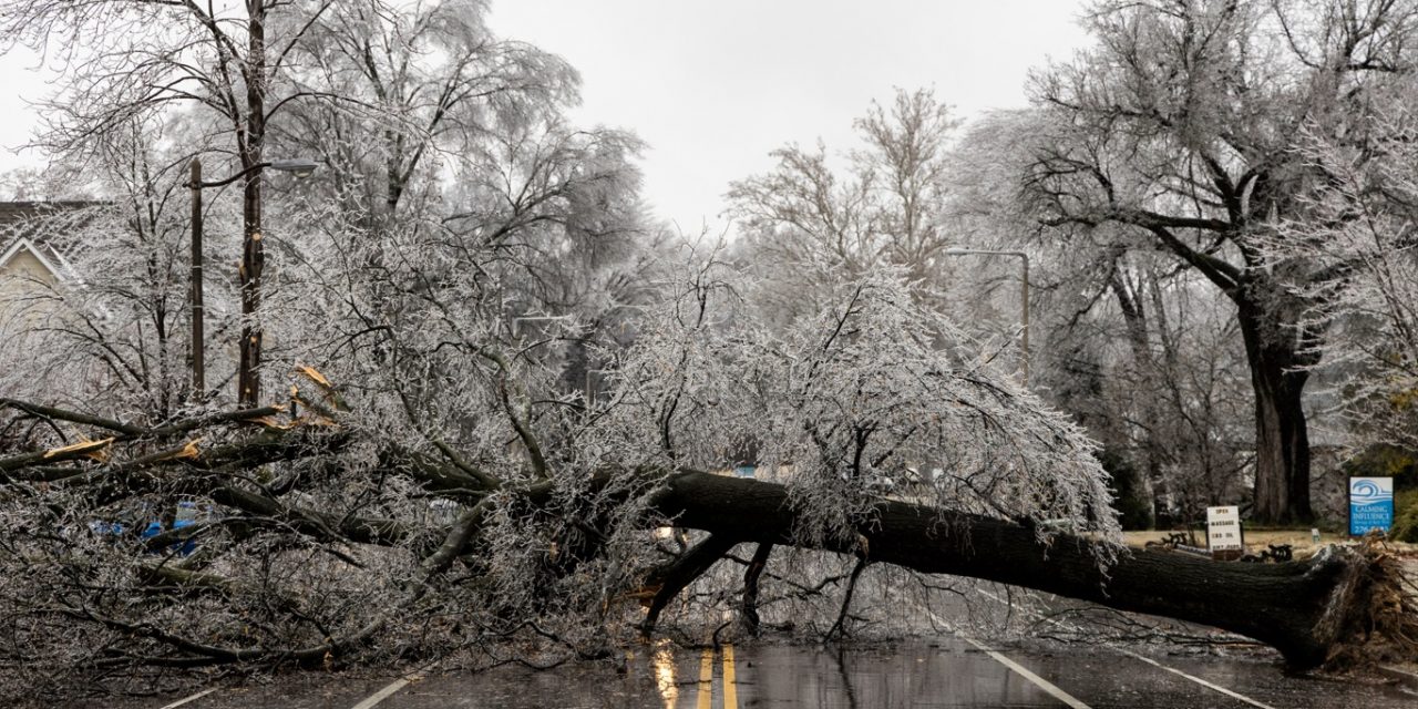
A powerful winter storm is expected to sweep across large portions of the United States from Friday through the weekend, bringing heavy snow, sleet and dangerous ice to more than 150 million people.
BRAD VEST/GETTY IMAGES NORTH AMERICA/AFP/METSUL
The storm comes as many Americans are still recovering from repeated snowstorms and persistent freezing temperatures, especially across the northern tier of the country.
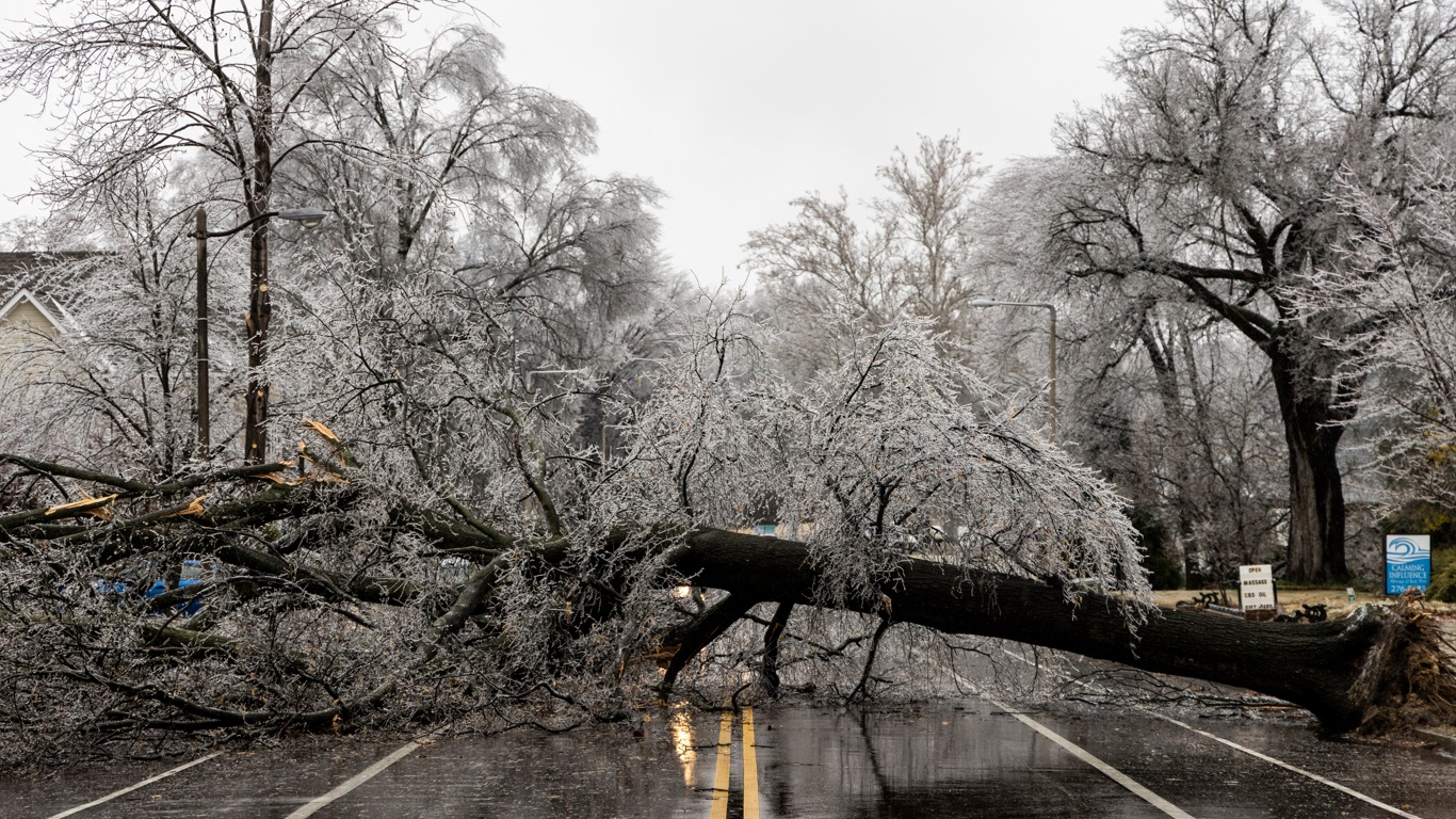
Forecasters warn that the most destructive element of this system may not be snow, but ice, capable of crippling power grids and paralyzing transportation.
Meteorologists say the storm could stretch more than 2,000 miles, affecting areas from Texas and the Southern Plains to the Carolinas, the Mid-Atlantic and parts of the Northeast.
Several southern states, which lack equipment and experience with major winter storms, could face particularly severe impacts.
Power outages lasting days are possible if thick layers of ice accumulate on trees and power lines. Travel disruptions are expected to be widespread, including road closures and thousands of flight cancellations.
Temperatures are forecast to remain well below freezing even after the storm moves east, allowing snow and ice to linger.
Emergency officials urge residents to prepare for prolonged disruptions to daily life. Forecast confidence is increasing, but uncertainty remains regarding the exact track and intensity of the storm.
Ice poses the greatest threat across the South
Forecasters say freezing rain could coat roads, bridges, trees and power lines with a thick glaze of ice across large areas of the South. Even a thin layer of ice can make roads treacherous, but accumulations of 12 millimeters or more could be catastrophic.
Utility officials warn that ice-laden trees and power lines may snap under the weight. Widespread power outages are a major concern, especially in Georgia, the Carolinas, Arkansas and parts of Texas.
Restoring electricity could take days if damage is extensive and access to affected areas is limited. Southern states generally have fewer snowplows and limited supplies of ice-melting materials.
Emergency crews could be overwhelmed by the scope of the damage. Schools, businesses and government offices may be forced to close for several days.
Hospitals and emergency services are preparing for increased demand. Officials stress that people should avoid unnecessary travel during and after the storm.
Arctic air collides with Gulf moisture
The storm is being driven by an unusually cold Arctic air mass plunging south from Canada. At the same time, a strong flow of moisture is streaming north from the Gulf of Mexico.
When these two air masses collide, they create ideal conditions for a major winter storm. Meteorologists describe the setup as extreme, even for the peak of winter.
A large area of high pressure over the northern Plains is funneling cold air deep into the southern United States. This cold air is expected to undercut warmer air aloft, leading to freezing rain and sleet. In some regions, precipitation may last more than 24 hours.
The prolonged nature of the storm increases the risk of significant ice accumulation. Temperatures may remain below freezing for days, preventing ice from melting. This combination raises the potential for long-lasting impacts well into next week.
Snowfall could reach historic levels in some regions
While ice dominates the southern edge of the storm, heavy snow is expected farther north. A broad swath of snow may stretch from northeast New Mexico and northwest Texas through Oklahoma, Kansas and into the Northeast.
Some locations could receive 15 to 30 centimeters of snow or more. In parts of the Appalachians, snowfall totals may exceed 60 centimeters. Major cities in the storm’s path include Dallas, Oklahoma City, Nashville, Atlanta, Charlotte, Washington, D.C., New York City and Boston.
In Oklahoma City, the storm could rank among the top five largest snow events on record. Snowfall rates may be intense enough to overwhelm road crews. Blowing snow and reduced visibility could make travel extremely dangerous. Interstates and secondary roads may become impassable for extended periods. Officials warn that stranded motorists could face life-threatening cold.
Travel disruptions expected nationwide
Transportation officials are preparing for major disruptions on highways and at airports. Thousands of flight cancellations are expected across the country through the weekend. Major airline hubs such as Dallas, Atlanta, Charlotte, Memphis and New York are likely to be affected.
Icy runways and aircraft deicing delays could ground flights for hours or days. Road travel across the South may be especially hazardous due to limited snow removal resources. Bridges and overpasses will freeze first, increasing accident risks.
Authorities urge drivers to stay off roads unless travel is absolutely necessary. Public transit systems may also experience delays and suspensions. Rail service could be slowed or halted in heavily affected regions. Travel conditions may remain dangerous even after precipitation ends.
Cold lingers after the storm departs
Even after the storm moves east, frigid temperatures are expected to persist. In many areas, highs may remain near or below freezing for several days. Overnight lows could drop into the teens or even single digits. This prolonged cold increases the risk of frozen and burst pipes.
Homeowners are advised to protect plumbing and ensure adequate heating. People without reliable heat face serious health risks. Hypothermia and frostbite are major concerns for those exposed to the cold. Emergency shelters may be needed in areas with extended power outages. Officials warn that icy surfaces may refreeze overnight. Recovery efforts could be slowed by continued cold weather.
Texas may see the first impacts
Some of the earliest effects of the storm are expected in Texas on Friday. Arctic air will surge southward across the state as rain spreads in from the west. Northern and central Texas could experience a wintry mix of snow, sleet and freezing rain. Temperatures may fall into the teens and 20s Fahrenheit by Saturday.
Road conditions could deteriorate rapidly, especially overnight. Forecasters caution that small changes in temperature could greatly affect ice totals. Power outages are a concern if freezing rain becomes dominant. State officials have activated emergency response resources. Residents are urged to prepare for extended periods without electricity. Meteorologists emphasize that forecasting ice remains especially challenging.
Officials urge preparation and caution
Emergency managers across multiple states are urging residents to prepare now. People are advised to stock up on food, water, medications and batteries. Those with medical equipment dependent on electricity should make backup plans. Officials recommend checking on elderly neighbors and vulnerable individuals.
Generators should be used safely and only outdoors. Drivers are warned not to underestimate icy conditions. Even short trips could become dangerous during the storm. Authorities stress the importance of following official forecasts and alerts. Conditions may change quickly as the storm evolves. Meteorologists say this system has the potential to be historic in some areas.