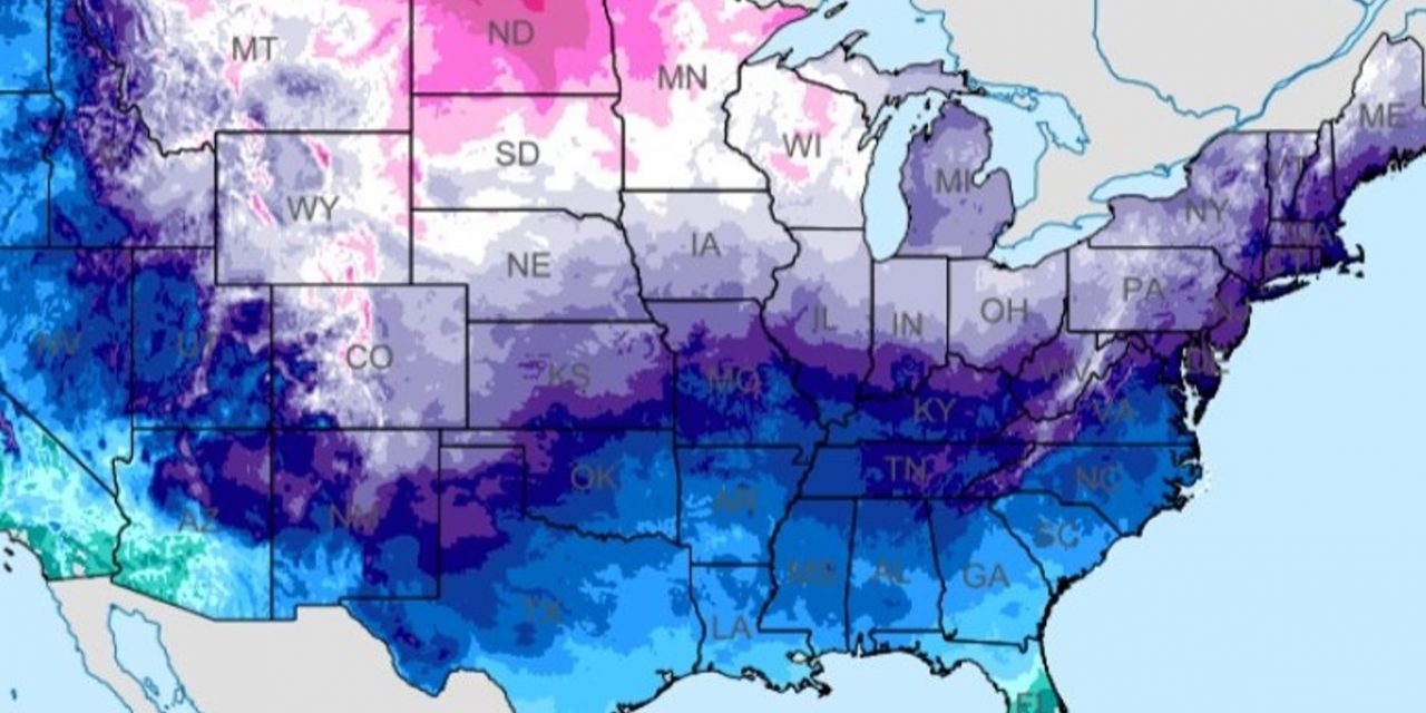
An arctic blast is set to sweep across much of the United States, causing temperatures to plummet by 30 to 40 degrees over the weekend and into the next week. The cold air will begin its journey in the Rockies and Great Plains before making its way to the Deep South and Great Lakes by Saturday night.

NWS
By Sunday, the East Coast will feel the effects of the frigid air. This severe cold snap will bring dangerous freezing conditions to regions as far south as Texas and will disrupt normal activities across the country. Donald Trump’s presidential inauguration, initially planned for Monday, has been moved indoors due to the bitterly cold weather.
The freeze will bring some of the coldest temperatures of the season, with high temperatures in the Plains and Upper Midwest expected to remain in the single digits to teens from Saturday through Tuesday.
Wind chills in these regions could plummet to 30 to 50 degrees below zero at times, posing a serious risk of hypothermia and frostbite to exposed skin. The Weather Prediction Center has issued warnings about the heightened dangers this extreme cold presents. In the central Plains and Midwest, daytime highs will only reach the teens or 20s, while northern Texas will see temperatures drop into the 30s and 40s.
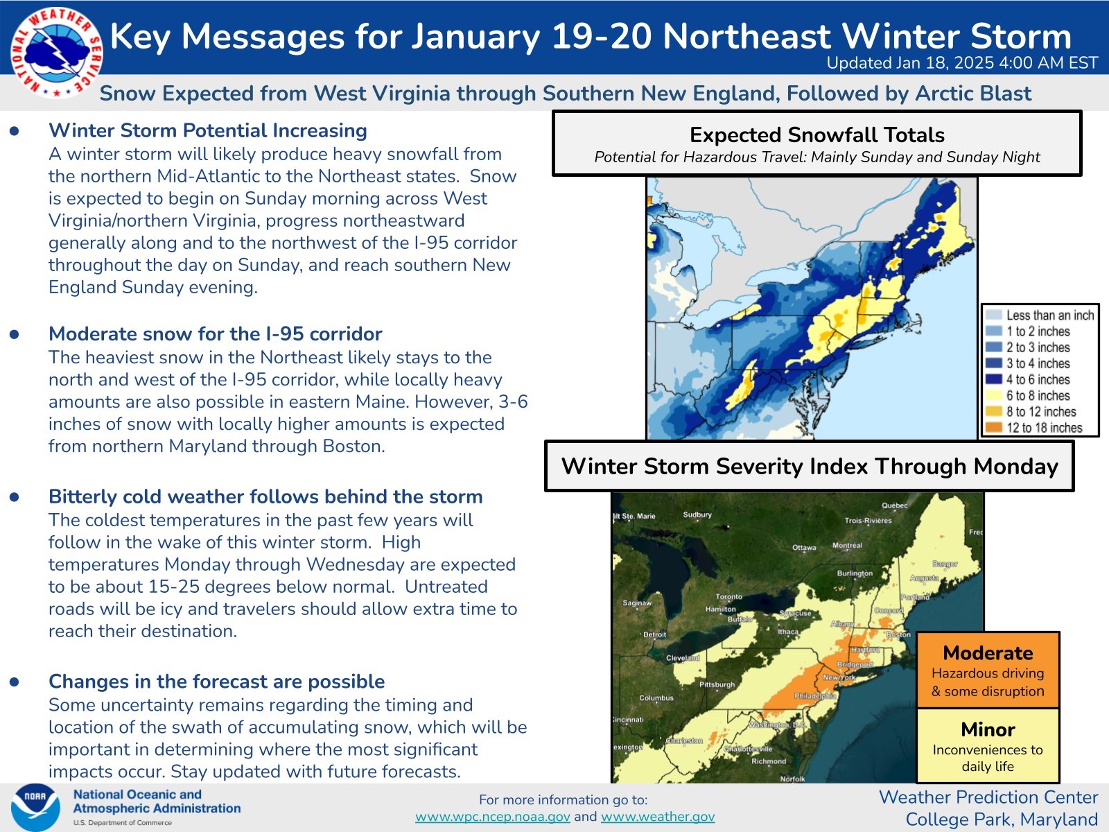
This blast of arctic air will prevent any significant thawing in areas still blanketed in snow from a storm earlier in January. Another winter storm is expected to hit the Mid-Atlantic and Northeast on Sunday, dumping several inches of snow before the arctic air sweeps through on Monday, delivering the coldest temperatures of the season.
In major cities, temperatures are expected to fall well below seasonal averages, with record lows possible in central and eastern parts of the country.
New York City will experience its coldest day on Tuesday, with high temperatures only reaching the teens and lows in the single digits. Wind chills will make it feel close to zero, while overnight temperatures Tuesday into Wednesday could feel as low as -5 to -10 degrees in some areas.
Dallas-Fort Worth will see overnight lows that feel like single digits or teens due to the wind chill, and Houston Marathon runners will face morning temperatures in the 30s, with wind chills making it feel like the 20s.
Washington, D.C., will be hit with snow on Sunday, followed by frigid conditions that could make Monday one of the coldest Inauguration Days on record. Temperatures are expected to hover around 20 degrees, with wind chills making it feel like the single digits. Overnight lows will feel below zero.
Boston will see bitterly cold weather starting Monday, with highs in the teens and 20s and lows in the single digits or below zero through Wednesday. Wind chills in the city could make it feel as cold as -10 to -15 degrees.
Chicago will struggle to rise above single digits next week, with nighttime lows dropping below zero multiple times. Florida will be spared from the worst of the freeze, but even the Sunshine State will see temperatures lower than normal. Central and southern parts of the state may experience freezing temperatures.

NOAA
Nearly 300 million Americans are expected to feel the effects of this arctic blast, which will bring snow and freezing conditions to many regions. The National Weather Service has warned of rain and snow showers around the Great Lakes and dangerously low wind chills across the Deep South.
This severe cold comes on the heels of previous winter storms that left heavy snow and ice across the country. In the South, over 40 million people were under winter storm warnings, and snowfall of up to 15 inches was recorded in parts of northeastern Kansas and north-central Missouri.
The polar vortex now descending on the continental United States is forecasted to impact vast areas with dangerously low temperatures and hazardous travel conditions. In Texas, areas in the northern part of the state may see light snow accumulations over the weekend.
The Dallas-Fort Worth area is predicted to have the highest chances of measurable snow. Washington, D.C., could see up to six inches of snow, and cold temperatures have forced Trump’s inauguration indoors. Massachusetts is expected to receive two to four inches of snow, with sub-zero wind chills early next week.
Connecticut and Rhode Island are forecasted to get up to three inches of snow in some areas. Illinois, particularly Chicago, will experience wind chills between -15 and -25 degrees, with sub-zero lows expected on Sunday and Monday nights.
NWS
Highs will remain in the single digits, and lake effect snow is possible in the region. Indiana will also see some snow, with amounts under one inch around Indianapolis, but the biting cold will be a bigger concern, as lows drop into the single digits.
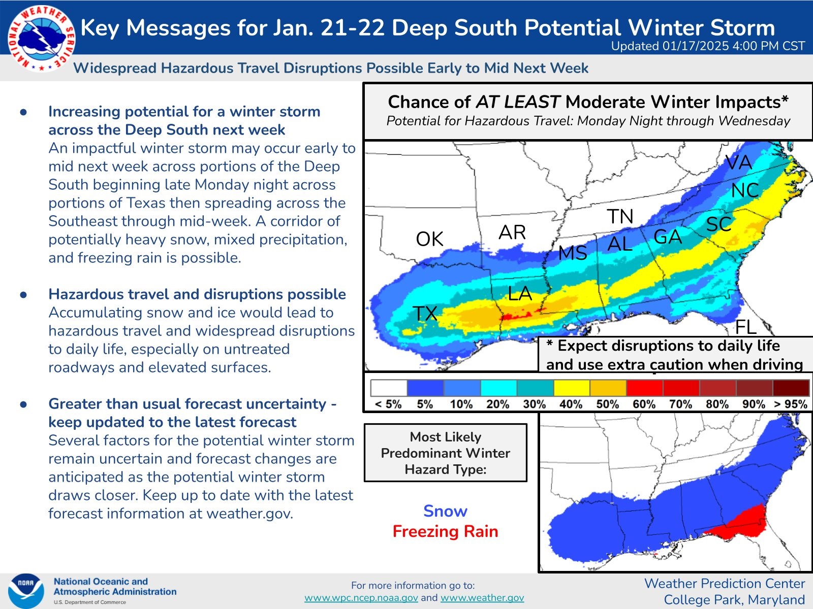
Georgia, particularly its northwest region, has a 50% chance of seeing snowfall over the weekend. While the southeastern United States won’t face the worst of the storm, it will still experience unseasonably cold weather.
Forecast models suggest the possibility of snow or ice in North Florida next week, though it is less likely to reach Central Florida. A storm system is expected to bring moisture and cold air to the state late Tuesday into Wednesday morning. The European model hints at a winter mix in North Florida, but meteorologists caution that it often predicts colder conditions than occur. While freezing temperatures are needed for snow, current models show mixed signals. Experts recommend focusing on weather trends rather than isolated predictions, as forecasters continue to monitor the situation.
The upcoming Arctic blast is expected to bring snow to much of Texas, with the Panhandle and areas near Houston and the Texas-Louisiana border most likely to see accumulation. Forecast models indicate up to three rounds of snow through next week, creating uncertainty in precise predictions.
The GFS model highlights two significant snow events: one in the Panhandle on Sunday and another in East Texas on Tuesday. It predicts heavy snowfall just north of Houston, with potential accumulations of 10-13 inches, though this seems unlikely. Cities like Austin could see 2-3 inches, while San Antonio and South Texas may avoid snow altogether.
NWS
The ECMWF (European) model forecasts broader snow coverage across the state, with three distinct events: one on Saturday night in the north, another on Tuesday in East Texas, and a third late next week in Central and Northeastern Texas. Houston could see several inches of snow, with 1-3 inches possible in cities like Austin, San Antonio, and Tyler. Even Laredo and Corpus Christi might experience minor accumulations.
Overall, this arctic blast is expected to bring record-breaking cold, significant snow, and hazardous conditions to much of the United States, affecting millions of people and causing disruptions across the country.